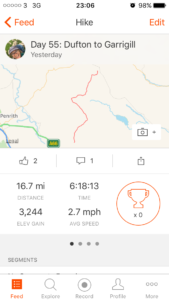
Total miles: 16.7
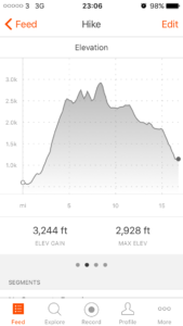
Elevation gain: 3,244 ft
Time walking: 10am – 8pm
Miles to date: 795.1
Wow, pretty epic day! It’s described as the hardest day on the Pennine Way and the first half definitely fits that description, with the unrelenting climb up to Great Dun Fell, the cruel up then down Little Dun Fell and up again to Cross Fell itself. Being the tallest peak in England outside of the Lake District I suppose I couldn’t really expect anything else, but gosh, it was a toughie!
I did my best to start early as I knew it would be a tough long day, and with the plan being to get to Alston I knew it was going to be a push. I struggled to get going very quickly though after yesterday’s long day, and feeding myself a good breakfast slowed me down too, so I didn’t actually start walking til 10am. I tried not to be annoyed with myself and focused on trying to feel strong and energised, which wasn’t particularly easy! The sun was half shining though and the weather looked promising despite clouds hugging the top of the hills when I set out. After a few twists and turns through fields and tracks leaving Dufton the path settled on a route and then sneakily, so that I didn’t realise it at first, started to turn uphill. At first the climb was gradual and pretty, flanked by a narrow strip of trees, before a “no no no we can’t go downhill!” descent to a stream and back up the other side along a farm track into fields of cows, mud and steeper ascent.
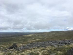
The path climbed up, up and still further up, leaving the mud behind and heading towards an attractive rocky cleft in the hill. The climb hadn’t felt too bad up until now, steady and achievable with a regular plod. Suddenly it became a lot steeper, with rocky or grassy steps in the hillside which required pauses to catch breath every few metres. Thankfully the view behind, out across the lowlands and to the edge of the Lake District, was well worthy of regular stops to admire. Today was the Dufton show and I could see the marquees standing proudly in a field outside the village and countless shiny cars lined up neatly in the parking area. I could make out the announcements on the tannoy perfectly, even this far away and this high up!
I paused on top of the rocky false summit of the first hill, actually nowhere near the top at all but I was determined to take on plenty of calories today so made the most of a handy seat-shaped rock to eat my peanut butter and jam sandwich. Even with that rest the climb to the first true summit was long and hard. At points I was trying to remember whether I’d ever found a climb this tough before. I’m sure I would have (Mount Kinabalu in Borneo is the obvious one – boy that is tough!) but right now it felt like the hardest thing I’d ever done! This was going to be a veeery long day at this rate!
Eventually I reached the top of Green Fell, a fairly flat summit, and got a good view of the next target – Great Dun Fell with its radio masts and big white ball thing on top. It was a squelchy descent to meet the road which winds down from the top (lots of cyclists – looks like a popular hillclimb!) and then a climb back up reach the top. It was windy up there and after worrying at the warmer lower levels that I’d made a mistake wearing my thicker long-sleeved base layer I was now glad of it! The views North over the moors were incredible. I spotted a large body of water over to the east and checked the map to find out which one it was. Turned out it was Cow Green – the reservoir I’d walked past the dam of yesterday! Wow, talk about taking the long way around! What I also didn’t realise until later in the day was that I’d also be circling back into some of the moor in front of me, later this afternoon…
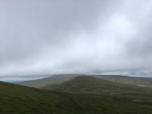
Cross Fell was looking tantalising up ahead and looked like it had just about decided to keep its head out of the cloud, but first I had to tackle Little Dun Fell. Smaller than Great Dun but stiff enough, when legs are tired from hours of constant climbing! And then, the biggy, Cross Fell itself. It actually wasn’t all that bad, once the initial climb up to Great Dun was made. It was tough, with thighs already wobbly and the knowledge that I was less than halfway on the walk, but it was doable. It was also wet, with multiple streams running down off the top, and the path often followed them (or do the streams follow the path?!), but it did mean I could make a handy water top up thanks to my now-working-again water filter! The last bit of the climb (at least the worst of it – it’s another flattish top with a false summit) involved picking my way up lots of loose rocks and moss. At the top, an elegant cairn but not the hoped-for trig point. Suddenly it was clear to see that the top was a fair distance away but thankfully over a fairly gradual climb. There wasn’t much path up here and I was glad of the visibility – today it was easy to see and aim for the circular stone shelter and trig point but in fog it would be compass all the way. The views from the top were 360 degrees and although the flatness of the summit meant the views to the north were slightly limited, the vista out west and south was stunning. The peaks of the Lake District were clear and I could even see a lake (no idea which one…right on the edge). The weather was variable over there, some hills were clear and the sharp ridges stood out clearly in the sun, others had wisps of cloud softening their edges and hiding their heads. They looked very tempting though. I wondered how long it would take me to walk from here. It didn’t look too far, maybe three or four days, although the air looked quite clear so it was probably deceptively far! And don’t worry, I have no intention of actually doing it…on this trip at least! 😉
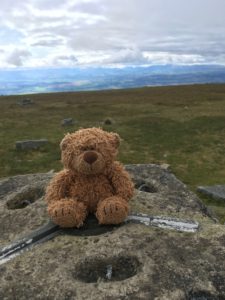
It was both quite surreal and satisfying to know I was standing on the highest point of my entire walk so far, and most likely the highest point of the walk in total unless (until) I climb Ben Nevis when I get to Fort William (weather, time and energy permitting). Either way, I feel like I’m racking up quite a few ‘highest’, ‘biggest’ etc this trip which is pretty cool.
I can see why they caution against climbing Cross Fell in bad weather – even with good visibility compass navigation was required to find the correct route off the summit. There were some useful cairns leading the way but I didn’t want to trust them 100% as you never quite know whether they are actual path markers or random piles of stones…these ones did seem to follow the Pennine Way though, helpfully. Again the path was invisible or faint at best – it was grassy and rocky at the top and the descent was wet so people had spread out to pick various routes among the boggiest bits. Sticking to the compass will get you down though – the route down meets (perpendicularly) a stony track so even if you are slightly off course you shouldn’t miss it. It was a soggy descent though with a few heart-in-mouth skids where I nearly ended up with a very wet and muddy bottom! The lower hills of the moor stretched out in front with one distinctive, gently curving, river-cut valley. It took me a while of looking at the view and comparing it against the map to work out the rough route. I was searching for Greg’s Hut and knew it was only a mile away but was confused that I couldn’t see it. Eventually I realised that the path doubled back on itself slightly down the hill which meant the hut was probably hidden beneath the incline. Even when I reached the track which led straight past the hut it took me a while to spot it, but suddenly I did. The roof at least! It was nestled behind an old spoil heap so was incredibly well hidden from view and as I lost height it disappeared completely. If I hadn’t known it was there it would have been a complete surprise to round the corner of the spoil heaps and suddenly see it there!
Greg’s Hut is a bit of a legend on the trail. It’s an old miners’ hut which was taken over by the Mountain Bothies Association in the 70s and is permanently open as a shelter/overnight stop. It has an incredible view! I was pleased to reach it as I had promised myself lunch and a cup of tea here. There’s running water just outside so I filtered enough for a cup of tea and got the stove going. It felt like a treat to sit on a chair inside out of the wind and I imagined how cosy it would feel with the fire going when it was windy and rainy outside (you’d have to have lugged your own wood up though!). It would be a real haven in bad weather! As I dried my feet off (for some reason I’d thought it would be a good idea to not wear my waterproof socks today…!) I read the visitors book and was pleasantly surprised at how many people stopped off or stayed here. Mostly Pennine Way-ers but also some day hikers and also a few End to Enders, including a couple whose journey I’d followed on Instagram! I saw that Sean had stopped off earlier too.
I looked at my route and could tell from the current time that I wouldn’t make Alston before the pubs stopped serving food so I decided to shorten my route. I was tempted to stay the night in the hut but it was still reasonably early and it would have put me behind by about 10 miles, so I decided to continue. I daresay I’ll be back though! The visitors book mentioned that Garrigill had camping behind the village hall (but that sadly the pub had closed down), so I decided to make that my destination, 4 miles short of Alston.
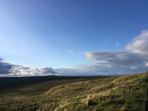
The rest of the walk was beautiful. I was incredibly lucky with the weather – I had a gorgeous mixture of golden sun and cloud – and the hills looked so picturesque, I really was getting to see the Pennine Way at its very best! It was also straightforward and fairly easy – mostly flat or downhill along a stony or gravel track, with just a few turnings to double check on the map. With the memories of the tough climbs of the morning getting softened by the gentler afternoon it didn’t seem like such a tough day after all. Mind you, it only took the odd small uphill or the steeper downhill sections to remind my legs of what I’d put them through!
A mile or so after leaving Greg’s Hut I suddenly saw another of the big white ball radio tower things on top of a hill. How strange, to have two so close, I thought! I looked more closely at the hill, and the two other peaks next to it. They looked familiar… I had a moment of panic – had I gone the wrong way? How was I just beneath Great Dun and Little Dun and Cross Fell after hours of walking?! I looked more closely at the map (this is where my “strips” of maps aren’t so useful…hard to see the bigger picture!) and realised that path does in fact loop around and almost double back on itself…and once again I wasn’t too far away from Cow Green reservoir either!
Reassured that I hadn’t made some disastrous map reading error I relaxed back into the beautiful walking and enjoyed hearing the numerous grouse with their familiar calls. I didn’t see a soul! On the northern horizon I could see some high ground with a big round hill and I have a feeling it may have been the Cheviots. It looked a long way away, but then it is about 5 days away…if it was the Cheviots then those hills marked the end of the Pennine Way. It will be strange once it’s finished, it’s such a long trail!
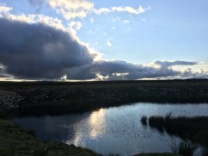
With a few miles to go, the sun shining and some delightful views back towards Cross Fell I debated finding a spot to wild camp up there on the hills. It would have been a glorious evening for it! I even found the near-perfect spot, some grassy patches next to some low rocky hummocks and with a stunning view. The only issue was there didn’t seem to be any water anywhere near, and I was still a bit further from Garrigill than I’d have liked. I decided to keep going and if I found water I would then find another good spot to pitch up for the night. Typically, now I had the idea of wild camping in my head, I didn’t find any water anywhere! In complete contrast to the countless streams tumbling down off the hills around Cross Fell, on this stretch of moor the water just seemed to be non-existent! Ah well, it wasn’t to be! Next time I’ll know to stock up on water along the way…!
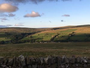
As if to ease my disappointment at not getting to camp up on the moor the universe provided me with another treat, this time in the form of a barn owl. It was out hunting, gracefully soaring along and occasionally swooping down towards potential prey. Serene and beautiful! I also found some raspberries just as I came into Garrigill, a pretty little village nestled in the valley, which was another treat. As I walked the last few hundred metres I saw a crowd outside a building which turned out to be a very open-looking pub! How exciting! I decided I would go and sort my tent out first then come back and see if they were doing food. The village hall was just around the corner and my heart sank slightly as I heard loud disco music coming from the hall. Ah, Saturday night… I headed around the back and there were a couple of kids and a man who had something to do with the village, who told me it was the annual village BBQ and disco. Oh dear! But he pointed me to the field and said I could camp, offering me some insect repellent which I gladly used as the midges were flying about in clouds. The tent went up quickly and I threw myself inside out of the midge storm, already feeling itchy, to think about what to do. I decided I’d check out the pub, if they did food at least I’d be away from the horrible biting creatures! I dive out of the tent, closing it quickly behind me and run to the hall, swiping midges from my face as I go. Urrrrgh they are horrible!!!! Some slightly bemused looks from teenage girls dressed up to the nines in the toilets as I appear in my hiking gear, and similar looks from the crowds in the pub. Sadly, pub not doing food as it only reopened today! Still, good news that it’s back open at least!
So, back to the tent and the midges, to cook one of my camping meals. A case of me putting water onto boil (which thankfully only takes a couple of minutes with my MSR Windburner, amazing piece of kit!), hiding in my tent all zipped up then doing as much as I can as quickly as I can in brief un-zipped spells. I’m just waiting the 8 minutes for the hot water to work its magic on my dinner when I hear the children running over. They are very cute and curious about my presence. “Are you camping?” “What are you doing!” “Are you making dinner?” Etc etc. I patiently explain that I’m waiting for my special chicken curry to ‘cook’ whilst being painfully aware that each second the tent door is open another ten midges make it into my bedroom… the children soon lose interest, as kids do, and ran off to play football, while I gratefully zip up the tent and tuck into my delicious dinner. Ten minutes later they are back, this time with whooping ghost noises. Sigh. “Are you in there?” they call. I stay silent for a few moments, wondering if they’ll leave. Nope. They come and start bashing on the tent. Argh! I open the door and smile and ask them (as pleasantly as I can when my beloved tent is under attack!) to please not touch the tent. They blame the youngest and run away again. Thankfully, they left me alone after that. I wish I did have a bit more patience, but after a long, tiring day all I want to do is curl up in peace and quiet and not get eaten alive by midges or small children! I keep thinking longingly back to that lovely spot on the moors…ahh the benefit of hindsight! Well, it’s all memories I suppose. And now at least I am getting an early night. Tomorrow is a big 22 miles to Greenhead, so I’m planning to be up early and walk the 4 miles to Alston for breakfast and to stock up on some supplies. It’s Sunday tomorrow, but I’m hoping something will be open! But for now, to the sounds of owls hooting, it’s time for a well earned sleep!