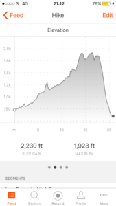
Total miles: 20.8
Elevation gain: 2,230 ft
Time walking: 9:45am to 7:30pm
Miles to date: 778.4
A long but thoroughly enjoyable day! Not as flat as the national trails website would have you believe (“it’s an unusually flat day, in fact there is more descent than ascent…”) but the climb was so gradual that I barely noticed it and there were plenty of stunning sights along the way, nicely spaced throughout the day. I was incredibly lucky with the weather – today’s walk could be quite miserable in poor weather as there’s a large section of remote moorland and pea-soup fog would make navigation a little harder and hide the incredible climax of the day – High Cup Nick. As it was I was dry until coming down off the last hill, thank you weather gods!
-
Not sure I’d call that a “flat” day..!
The day started out with a slight shock as we weighed my bag out of interest. It turns out it isn’t 18kg or even 20kg as I’ve been telling people. It’s 23kg! Yikes! No wonder it feels a bit heavy swinging it up onto my back…to put it in perspective that’s an overweight check in suitcase! That was with 3 litres of water though, so I promptly dumped a litre and vowed to make use of my water purification tablets! After that slight amazement I headed out onto the trail feeling well rested and strong after my rest day, looking forward to what lay ahead.
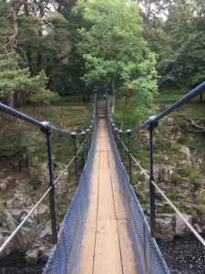
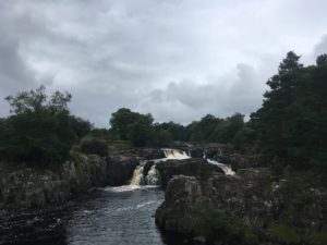
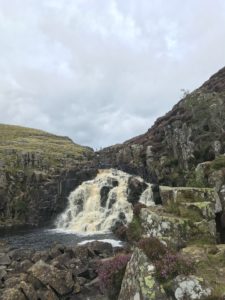
The first few miles went through farm fields and a series of stone stiles (thankfully none as tall as the other day), not the most interesting of walking but fairly easy going which made for a quick start to the day. After a while the path joined the banks of the wide but shallow River Tees which was a pleasant, gently chattering companion, with the path picking its way over a few rocks and tree roots here and there. Three and a half miles in and things start to get interesting….the banks become mini limestone cliffs and the river narrows slightly and becomes more vocal. A couple of small waterfalls provide the warm up act to the first major waterfall of the day – Low Force. I presume it is called Low Force because of its downstream position on the river relative to its rival, High Force, as although it certainly isn’t as high, I think it is more splendid than the latter. It’s certainly easier to view well – a (very bouncy) bridge leads over to a grassy and rocky area which looks over the multiple falls that make up Low Force. I sat there for a while munching on the first half of my picnic (scotch egg, yum! Have never eaten so many scotch eggs in my life!) and just taking in the vibrant energy of the falls.
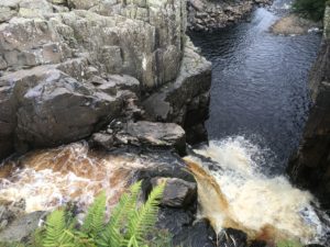
On the way to High Force, only about a mile and a half upstream along an easy path, I saw a little stoat run along ahead of me and dive into a bush. I haven’t seen a stoat in years! I could hear High Force before I could see it, in fact at first I wasn’t sure I was going to be able to get a good view at all! The main viewing point is on the other side of the river, from below, and I remember seeing it from here when we made an overnight stop nearby on our way up to Durham. As it turned out, the path on my current side of the river came out on top of the falls and heading cautiously to the edge (having deposited my bag a safe distance away) I could get a great view down the series of falls from above, a view you can’t get from the main viewpoint. It’s a powerful waterfall! Unlike at Low Force, where the river splits and tumbles over the rock face in different places, at High Force it all pours down the same chasm and is spectacular in its power.
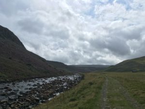
From High Force the path quickly leaves people behind and heads off up the valley, past a busy little quarry and up into a wide dale overlooked by tall but gentle hills and waterfalls on one side and steep limestone crags and purple heather on the other. It is quiet and peaceful, once the industry of the quarry is left behind, and the path is pleasant and grassy with some rabbits for company. After a near miss encounter with a little civilisation (a farm, a bridge, two men fishing and a YHA hostel a quarter of a mile up the road) at Langdon Beck it’s back to wild country again and a riverside path for the few miles to the next highlight – Cauldron Snout, another waterfall to add to the collection. The river flows through a wide, shallow valley here and the wind coming down through the hills was unexpectedly intense. Walking for several miles against a chilly headwind took away some of the pleasure of the otherwise-serene valley, and several rocky scrambles along the river where it ran close to limestone outcrops above also served to slow me down. It was very pretty though and had it not been so windy and had I not planned to stop at Cauldron Snout it might have been a nice place for a lunch stop! Whilst picking my way over the rocks I met a couple coming the other direction. They’d had a disappointing morning, with pea-soup fog up at the top and a tricky scramble down Cauldron Snout. I hoped I’d be more lucky!
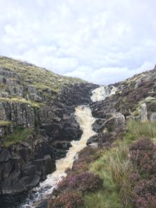
A little further on and I was rounding each bend excitedly expecting to see the waterfall. But Cauldron Snout kept itself well hidden until the last minute! I wasn’t sure what exactly to expect but I had been warned of a scramble up the side of it, which I was a little nervous of but I was glad at least that it had not been raining. When I finally rounded the final bend the waterfall did not disappoint. Tumbling water cascaded down over limestone slabs from about 20-30m up, the white of the foam contrasting with the black of the wet rock and the purple heather growing in cracks at the side. The scramble wasn’t so bad – a few bits where I had to pull myself up on my knee using rocks and heather but not as scary as I’d feared. It helped that I could see Eunice waiting at the top for me. Talk about amazing friends – she was staying with a friend in Yorkshire and drove nearly 3 hours (and walked over a mile) to meet me for a picnic lunch and give me a hug! I was thrilled to see her, not just for the hug but also because I hadn’t had phone signal for 3 hours and had no idea if she would actually make it and be able to find me!
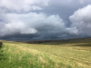
It was a welcome stop, sheltering out of the wind behind the bridge with the massive dam of Cow Green reservoir as a view. I was glad of my proper lunch following yesterday’s food shop as I was starving! The last couple of weeks my need for calories has really kicked in and I’m struggling to eat enough. It was as much as I could do not to eat tomorrow’s lunch too but I knew I’d regret it if I did! All too soon I had to head off as I still had another 10 miles to go and some even more remote terrain to cross. Thankfully our pleas to the sky seemed to send the dark clouds the way I had come rather than the way I was going, and I was hoping for a dry end to the afternoon.
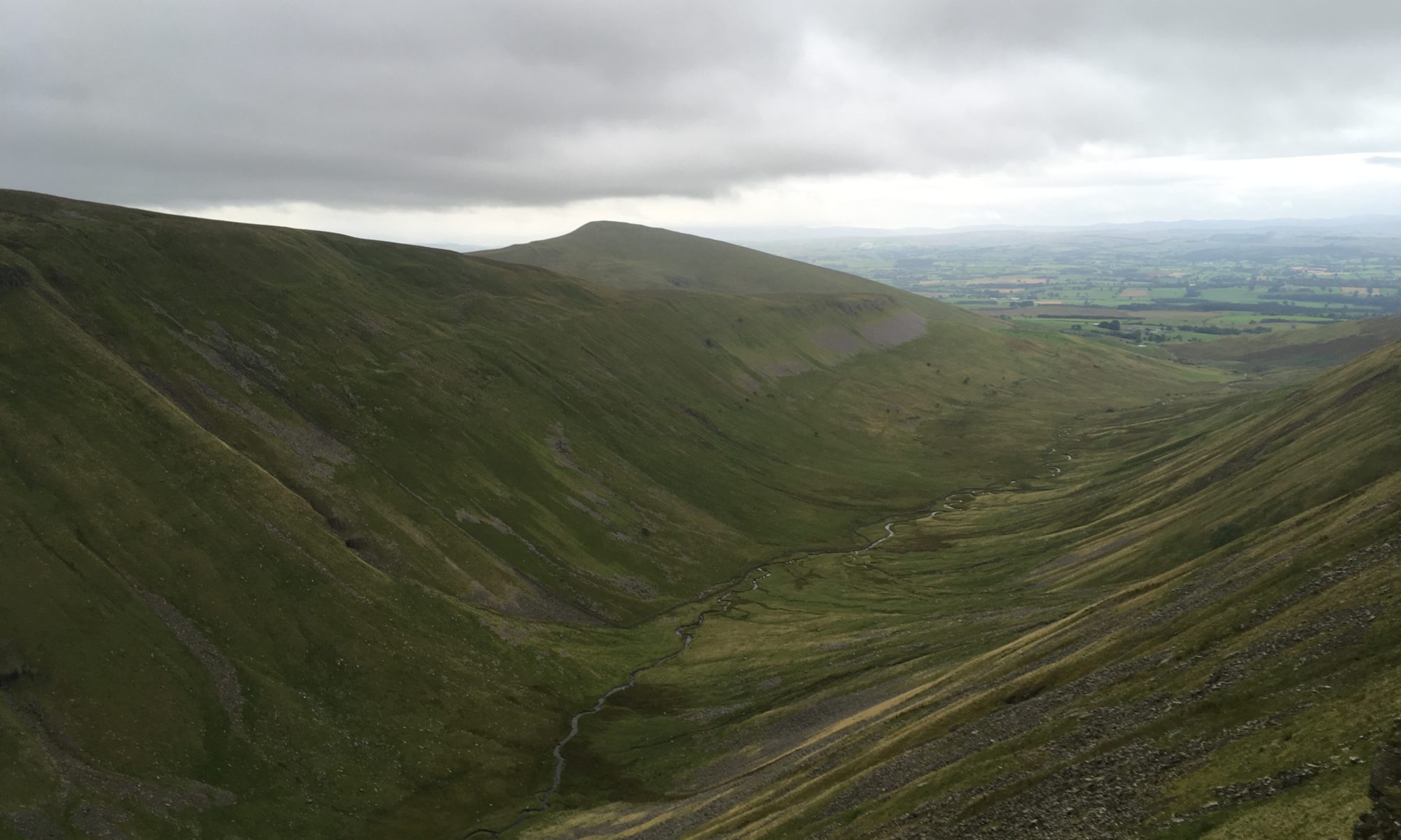
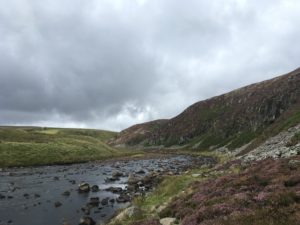
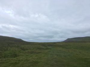
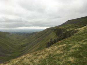
The first few miles after leaving Cauldron Snout were along a tiresome gravel track, up over a lovely moor, one side of which was an MoD danger area, warning signs dotted every few metres at the side of the track. The Pennine Way eventually leaves the track and heads down over squelchy ground (cue my first calf-deep sinking of the day) to the banks of Maize Beck which it then follows for a couple more miles. The beck was fairly low and it would have been easy to cross at several points, even when I spotted the footbridge I was tempted just to try to make my way across on the stones, before deciding it would be far more sensible to use the bridge, as it was there. The moor was fairly exposed and I found myself once again being thankful that the weather was clear! It felt like a long way, across that moor, knowing that at the other end was High Cup Nick, a sight that some describe as the best sight along the whole Pennine Way. There is no hint of it though, as you approach. It looks as though you are in a very shallow, wide valley up high, with moorland for miles, but as you start getting closer you start to feel there might be something more up ahead. It looks almost like the route just ends, or disappears over the edge, and suddenly you see what the edge is. The moor ends abruptly, with sheer limestone cliff edges dropping tens of metres to a steeply sloping valley, shallow at this end but deepening dramatically – 100m or more – as it curves away at either side into a slightly pointed U-shape. My first reaction is ohhh, wow, that’s awesome! But as I head around one side, where the path hugs the edge quite closely, the geological beauty just gets more impressive and I can’t help but keep stopping to gawp at it! It’s deeper than I first thought and the steep sides are gouged with scar-like crevices running down the side, presumably full of cascading water during wet periods. A winding stream ribbons at the base of the valley far below and apart from a few sheep dotted here and there it’s completely deserted! No car parks up here..!
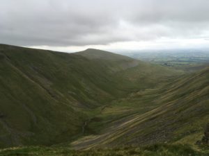
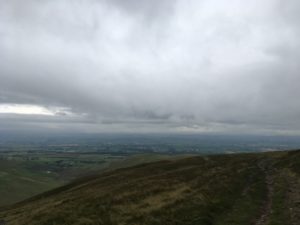
The path follows the edge of the valley for a while, fording streams below mini cascades and the occasional small scramble. There were a couple of points where I was glad I don’t suffer from vertigo but on the whole it felt safe, yet thrilling. Sadly the path does eventually veer away from the valley to take a slightly more gentle descent down into Dufton, but as there were some black clouds headed my way it seemed like it was probably a good time to be coming down off the hills! And it really was coming down – for the first time in what seems like forever the land that stretched out in front of me was the patchwork fields of lowlands rather than moorland. I knew I’d be back in the hills tomorrow but it felt strange to be leaving them, however briefly. Out there was ‘normal’ life…up here was peace and freedom!
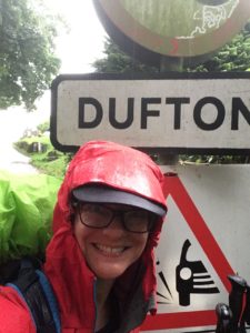
But descend I must, and the first bit wasn’t too bad, I even had some blue sheep to entertain me. Ok, they weren’t actually blue, but they were so covered in blue paint that for a moment they really did look blue! I also saw some beautiful black horses (Fell ponies, I think) which presumably are owned by someone but were free to roam the moor. The last bit of the descent was along more gravel track and it finally started to drizzle with rain so the waterproofs came out. Gravel track, tough on tired feet, eventually gave way to tarmac (possibly even harder on tired feet) and the rain got heavier until I finally came into the little village of Dufton. The woman in charge of the campsite spotted me coming and took me to a quieter section of the site (apparently they had some groups in for the bank holiday), where I spot a familiar looking tent. Sure enough about 10 minutes later I hear a cheerful welcome in a strong New Zealand accent – it’s Sean, my old-skool tough-as-old-boots Gandalf lookalike! The rain stopped for me to put up my tent and seems to be staying away now. I can cope with that! Sean offers me a cup of tea as he’s making a brew, very welcome as it’s getting late and I need to get my dinner on! So somewhat in reverse, I have cookies with my tea then eat my main course. Exhausted after my long day, I fall asleep whilst writing this blog…! Tomorrow is the toughest day of the route – 20 miles and up over Cross Fell, the tallest point in England outside of the Lake District. Two long days in a row isn’t ideal, but that’s the way it goes!