
Total miles: 11.8
Elevation gain: 2,193 ft
Time walking: 9:30am – 4pm
Miles to date: 642.5
Today was a shorter day though still pretty big on elevation, and after yesterday I was grateful for the slightly easier walk. I was also lucky with the weather again!
The day started off well, dry putting the tent down, an expedition rehydrated breakfast with tea, followed by a bacon and egg roll from the campsite shop-come-mini-cafe that Stuart bought for me. A double breakfast is always a win!
Stuart and I walked together today and it was nice to have a bit of company again. He has walked the Pennine Way before so could remember the route which was handy, not that route finding was particularly challenging today thanks to more flagstones in the tricky bits.
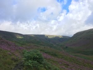
The first few miles of the day took us up a pretty heather-clad valley with a couple of stream crossings and a fairly strenuous climb up to Laddow Rocks. My thighs could really feel yesterday’s climbs and I was a bit nervous about how tired I felt. I kept reminding myself that yesterday was one of the hardest days and that it would get a bit easier for the next few days, otherwise I think I would have worried about how I would keep going! Thankfully the views along the valley and back the way we came were worth it. The sun sent cloud shadows scuttling over the hills opposite and the white and black of the stream bubbling below contrasted beautifully with with green and purple of the heather.
As we climbed higher we started to see the hills we had come over the day before – right back to the Kinder plateau! It looked a long way away! Eventually the path reached the top of the wide valley and headed across moorland steadily climbing up to Black Hill, the highest point of the day. Once again I was grateful for the flagstones, whilst they are a little tedious I bet that is nothing compared to wading through sticky bogs for miles…! Stuart has long legs and a lighter pack than me and he makes rapid progress, he has to keep stopping to let me catch up. He’s very patient with me, but I do worry about slowing him down. A black cloud comes our way and it starts to spit with rain so we quickly don waterproofs, knowing we are due a shower. Five minutes later (as I’d predicted – I told Stuart of my (lack of) luck with waterproofs and rain showers…) the sun was back out and the black cloud had dissipated. That was it for rain for the day!
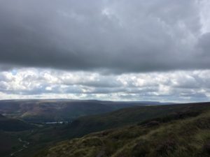
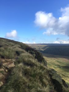
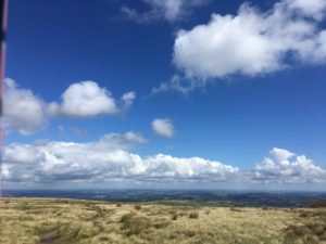
As we came over the summit of Black Hill we gasped as the view suddenly stretched out in front of us. It was big. Biggest of the trip so far I think, the only potential rival being the Black Mountains day! Right from east to west the country just stretched out, with cities touching the sky on the horizon, and the onwards moors to the north. There is a massive but slender tower on top of a small hill visible from here (and for miles around) which apparently is a TV mast. Grandest TV tower I ever saw!
After a long steady descent from Black Hill, pausing for a brief lunch with a view, the path scrambles up the side of a small clough and pops over a road before dropping down again to Wessenden Resevoir, the water a bright blue against the green hills in today’s sun! The path follows a track which gradually descends to be almost level with the reservoir and it makes for pleasant, easy walking. We see a young man walking towards us, we guess from his suntanned face and big rucksack that he has been walking for a while so stop to chat. It turns out he is walking John O’Groats to Land’s End! I’m excited to meet a fellow end-to-ender and we swap stories for a bit. He has been camping pretty much the whole way, hats off to him!
A bit further along the path dropped steeply down to the stream that runs down the valley from the reservoir, then straight back up the other side. Jelly babies were required, and a rest at the top on a helpfully placed slab of concrete. The good news was that this marked nearly the end of the ascent for the day (for me at least!), and I was glad I only had a couple of miles still to go as my legs were feeling pretty heavy.
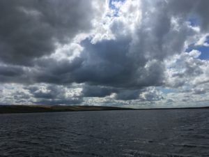
The final couple of miles took us back up into moorland past some smaller reservoirs where the wind was fierce, the water choppy and the sky moody. It was quite atmospheric up there! Dropping down slightly we could see a little boating lake and a pub, but sadly for us the pub wasn’t open in the afternoon. For me the car park next to the next little reservoir marked the end of my day (so happy to be finished so early for once!) but Stuart had a fair few miles still to go as he is pressing on more quickly than me. We said farewell, sorry that our paths wouldn’t cross again on this route, and he headed off up over the next bit of moorland.
Tonight I have had the treat of a lovely bath and a massive BBQ at Jane’s house. Jane is the cousin of a friend’s mum and she and her family are so lovely, I’m really thrilled that they offered to put me up for the night! And my room has beautiful views out to a heather-clad hill so I don’t feel too far away from it all. I’m really tired now and the bites from last night’s midges are starting to itch like crazy, argh! I’m so glad I’ll be missing the worst of the Scottish midge season! I’m not quite sure yet what tomorrow will bring – my notes and what I’ve read on the national trail website differ in terms of distance for the next section – but I’ve decided to add on a couple of miles to get another hill out of the way and to shorten the next day (a longer day) a little. Camping again tomorrow, yay!