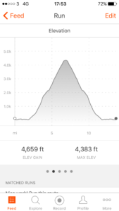
Total miles: 13.6
Elevation gain: 4,659 ft
Time walking: 9:30am – 5:30pm
Miles to date: 1,156.8
I am so happy I managed to tick off Ben Nevis! Last night I was feeling so gutted that I might not be well enough to climb it and this morning I still wasn’t feeling 100%. Even just a little way up the mountain path I almost turned back as I had a few minutes where I was feeling real pain in my shoulder/rib/lung (unfortunately while the osteopath managed to loosen me up a little he wasn’t able to fix the main issue I have) and I had to rest on a rock, almost in tears. On top of that the wind was forecasted to be 35-50mph (that’s pretty strong!) so I wasn’t sure if it would be safe to go all the way and knew that realistically I may well have to turn back before the top. But, I made it!! And I am so pleased!
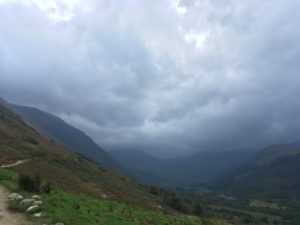
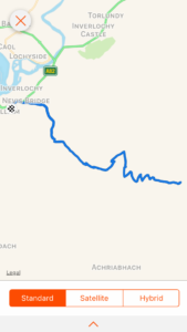
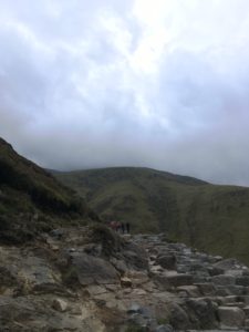
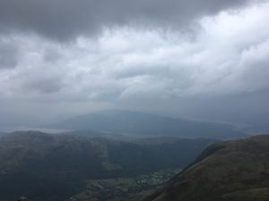
I made things a little harder for myself by deciding to walk from the hostel (which added 1.7 miles each way) rather than get a taxi, but I figured at least it would give me a warm up! I started to head up the hill itself about 10:15am and it was already a bit blustery and the hills looked moody. It didn’t bode well! It was beautiful though, in a wild Highland sort of way, and despite not feeling 100% it did feel good to be out and moving again, and it was heavenly to have such a light pack! Apart from the aforementioned pain, which came and went the whole day but thankfully not as badly as in that first section, I felt quite strong and made good progress up the first section of the track. It’s amazing how much easier it feels without so much weight on my back! The views were already great, looking up Glen Nevis and across to Dun Deardail, the hill fort I’d visited a couple of days ago. The track was fairly busy, but then it always is, it’s amazing how many people actually climb the Ben. I inwardly rolled my eyes each time I saw someone climbing in jeans, loose ankle boots or fashion trainers…at least no flip flops today, thank goodness!
The path goes up, up and up, as you’d expect for a mountain. It was a bit of a slog in that the path isn’t that interesting – a long straight gradual climb followed by a series of interminable zigzags – but it was eminently doable. It was rough and uneven in places but you could tell that thousands of people are able to climb it each year. It was tough, but I can really tell how my fitness has improved as it didn’t feel nearly as hard as Great Shunner Fell or Cross Fell, despite being much higher. I guess not having the heavy pack makes a huge difference though! Halfway up there were some rangers working on improving one particularly badly eroded section of the path. They were manhandling huge blocks of rock, breaking them up and rearranging them to make a rough path. A heavy, muddy task, but they were doing a fantastic job. I just hope the next thousands of hikers appreciate it!
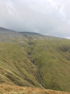
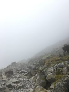
There was a stunning view of the series of waterfalls as the Red Burn cascades off the mountain across the gulley, around the top of which the path then curves to meet the burn itself, with views back to the little lochan nestled in the saddle between Ben Nevis and Meall an t-Suidhe. And then, the zigzags begin! The path is rougher here, cut into the scree-covered slopes, but it is still obvious and clear. I meet the clouds one zigzag in but it’s the wind that is more of an issue. It’s not constant, thankfully, but comes in fierce gusts that nearly blow me off my feet. Slightly disconcerting when you’re on the edge of a tall, steep mountain! Thankfully most of the time I get an advance warning, hearing it blow up over the hill towards me, but not always! Sometimes it is so strong I consider turning back, but then it drops again, so I continue, carefully!
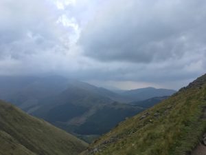
The fog is eerie. It is strange how one moment I had far-reaching, if a little hazy, views over Glen Nevis, Loch Linhe, Loch Eil and back towards the last day of the West Highland Way, and then I was in mist and cloud, not even able to see 20 metres in front of me. The sound changes too, and suddenly I could be on the mountain on my own. It is eerily quiet, other than the gusts of wind that blow up or down over the slopes and the occasional chink or clatter of loose rocks which give away the not-too-distant presence of a fellow hiker. Then a figure or two would emerge from the mist, shadowy at first, then some definition and then colour, a smile and hello and then they were past, fading back into the mist once more. The hikers coming down look cold and damp. I’ve already put on an extra layer and my gloves, the temperature difference is noticeable even without the wind. I debate putting on my waterproof jacket but decide against it as I’m warm from the walking. I later regret the decision as I get very wet by the time I get to the top! It’s not raining, it’s just the cloud!
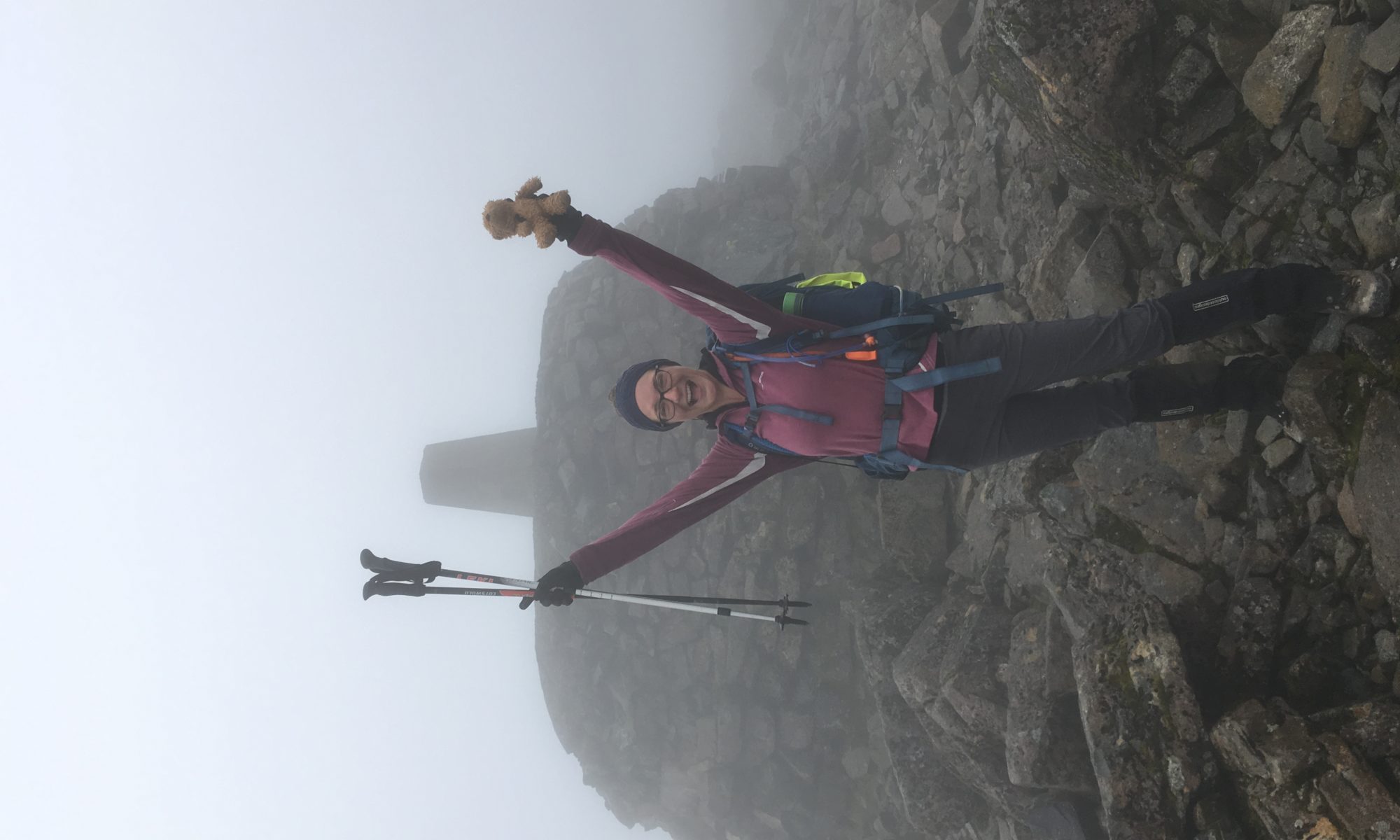
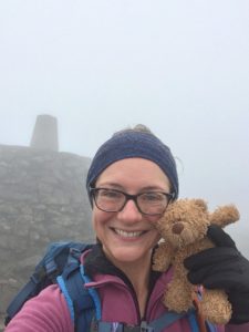
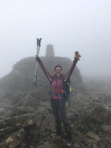
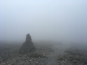
The further up I get, the thicker the cloud gets and the more faint the path. It is still fairly straightforward to follow – the path is a loose rock and gravel of a pale grey and white whereas the surrounding rocks are more of an orangey brown and larger, but it still took focus to make sure I didn’t lose the path in the poor visibility. There were several large cairns on the way, which loomed out of the mist as I drew close, although randomly (and confusingly!) there were a few that weren’t actually on the path. Nearer the top the hikers coming back down gave encouraging cheers of “you’re nearly there now!” which was good to know – I knew where I was on the map but there was nothing to give away my whereabouts by looking around me – I could have been anywhere! Very near the top the path goes near a couple of the steep corries of the northern slopes – they suddenly appear, dropping down into nothing, heart-lurchingly close out of the mist. I pay extra special attention to the path! Then, suddenly, a dark mass looms out of the fog and I realise I’m there! The dark mass was a memorial cairn (or something of that nature), and the old observatory/restaurant building. There is an emergency shelter up there too, and then of course the trig itself! Of course there was no view but it was still pretty awesome to be up there, if a little cold and wet! I didn’t stay long, I was aware I was a bit damp and I had the long descent to safely get through, but I took the obligatory summit selfies and had a celebratory chocolate bar before starting back down.
Cautious of tales of people straying from the path and falling down the northern corries or the notorious five-fingered gully I very carefully followed the path, ready to get my compass out if necessary. I was a tiny bit disappointed but also massively relieved that my compass wasn’t needed and the cloud wasn’t quite thick enough to obscure the way completely. I’d still highly recommend knowing how to navigate off the summit by compass if necessary though! Once off the trickiest bit the way down was easy, and not as hard as I thought it would be – once again it’s amazing what a difference not having the heavy pack makes! It will be a bit of a shock to have it back again tomorrow I think…! After a few zigzags I suddenly emerged from the cloud like it has never existed. It was bizarre, one moment misty, damp, poor visibility, next moment, suddenly I could see! I looked behind me, and yes, the cloud was still there, but it literally just hovered at a certain height and below that line it was clear. Still windy though, in fact I think it was windier than on the way up. I made my way down as quickly as I could safely, keen to get back to the hostel for a nice hot cup of tea! It still took nearly 3 hours, but it didn’t feel so bad and it was nice to have the views again.
Part of me was tempted to see if I could hitch a lift back into town (hitch hiking seems pretty popular and successful up here!) but ended up just walking back gently to try and walk out some of the inevitable post-climb stiffness. I reached the hostel at the very civilised time of 5:30pm and the evening has been spent relaxing, showering, eating and planning the next few days. Unfortunately I haven’t managed to pack my bag as planned as people in my room went to sleep early, so I’ll have to be a bit efficient and get it all done in the morning. Tomorrow I hit the road again, for leg 7 – the Great Glen Way. I’d planned to do it over 5 days but a fair few of the guides I’ve read seem to think it’s doable in 4 so I’m going to give that a go and then that gives me a bit more flexibility with the next bit. Camping again tomorrow and then, well, let’s see what the weather does… 😉