

Total miles: 11.1
Elevation gain: 825 ft
Time walking: 11am – 5:30pm
Miles to date: 997.1
An unusually short and flat day!! Day one of the Clyde Walkway which follows the River Clyde from the New Lanark World Heritage Site to the centre of Glasgow over 40 miles. A leisurely start, a leisurely walk, a leisurely evening…a pretty good day really, although it feels strange to not cover more miles!
We woke up to the sound of the river but no rain and after packing up inside my tent I peeked out to see damp grass but pale blue sky and the fresh autumnal hint of a beautiful morning coming up over the trees. While I tried to dry out the outer tent a little (never really going to happen on a cool damp morning!) I made us some tea and myself some porridge (Anneliese doesn’t eat porridge, crazy woman). Considering the rain last night I had thankfully managed to stay fairly dry and I couldn’t believe our luck with the dry morning! It was lovely to be able to drink tea and eat breakfast outside! A couple of dog walkers came past while we were packing up and they both stopped to say hello. I keep expecting people to tut disapprovingly at us camping but of course it is allowed up here, and besides, everyone is so friendly up here I don’t think they’d tut even if it wasn’t allowed!
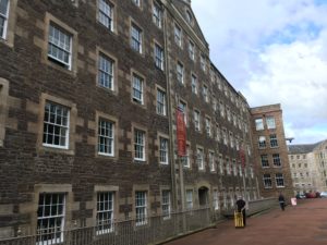
We finished packing up at about 9am, not in any hurry as we were planning to head to the visitor centre cafe just down the hill for (second) breakfast. I think we were the first people in the cafe and the manager stopped to chat with us, fascinated about where we had come from. We ordered our breakfast (scrambled eggs for me, pancakes with maple syrup and bacon for Anneliese) and the obligatory cups of tea and settled into the nice comfy chairs. We hadn’t even walked half a mile and it felt good to sit down! Checking the map we only had 10-11 miles to go today so we were in no rush to head off. We are wild camping again tonight so we figured we’d make the most of a bit of comfort while we had it! Another cup of tea and a shared slice of a weird but delicious coconut and marshmallow cake (who says you can’t eat cake for breakfast?) and we finally made a move. We wandered around the site for a little in the sun, admiring the huge but beautiful former cotton mills, water wheel and the river just in front. It all looked exceptionally tidy and well-ordered, it was strange to think that some of the buildings dated back to the 18th century. It was a fascinating place, both a museum and a living working village. I couldn’t imagine living there, it would almost feel like living on a period drama film set, were it not for the modern cars and bus loads of tourists!
It took us a few wrong turns to find the path that would lead to the river (for once, the map really didn’t quite depict reality as far as the path was concerned!). After a steep uphill climb back to the road we finally picked up the path and headed down into the woods, first gentle and quiet conifer woods, then brighter and livelier deciduous woodland, the river flowing just below. It was strange to think that the quick but quiet water had just come down through all those incredible waterfalls. How quickly it can go from peaceful to torrential to peaceful again!
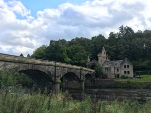
The path undulated up and down along the river with one steep zigzagging climb up to the pretty Castlebank Park, before dropping back down to cross the river on the old (possibly mediaeval) Clydesholm Bridge. The path then followed a busy main road through the village of Kirkfieldbank before dropping back to the river and crossing it at another powerful weir. Shortly after the weir the river tumbles over another set of spectacular waterfalls – Stonebyres Falls – doubtless less famous than the Falls of Clyde and sadly less visible but still incredibly beautiful and powerful. Masses of water literally just pours off sudden edges to crash into boiling pools below, mist being caught in the updraft and creating a hazy veil. One of the falls tumbles over a v-shaped cleft in the river bed and the result is spectacular. Sadly there was no suitable place to get a decent photo but I can still picture the amazing sight and hear the noise!
The path kept close to the river all day, passing by a mixture of fields and woodland and a weird deserted holiday park. Those places still give me the creeps! We stopped in Crossford (with another pretty bridge) to see if the pub was open (perhaps a long shot for a Monday lunchtime…) but not only was it not open it had shut down! Never mind, we continued on our way knowing there was a pub/hotel near Maudslie Bridge (our planned stop), if we felt like it. This pub was still out of our way though, a kilometre back along the other side of the river from the bridge, at the small village of Rosebank, and as we got closer we decided we’d actually rather just find a camping spot, get our tents up to dry and make the most of actually arriving not only in the daylight but in the sun, before 6pm!
When we first arrived at Maudslie Bridge we were a bit dismayed as all of the flat unenclosed land along the river was knee high with grass and thistles…not exactly prime camping spots! The map said that about half a mile further on the path returned to steep woodland so we knew we had to find somewhere in the vicinity of the bridge to camp or walk several miles further on. We kept going past the ridge, passing a few fishermen on the banks of the river, then came across a flat-ish spot beneath a beech tree, right next to the path and a few feet from the river. It wasn’t ideal, but it was by far the best we had seen! At least it was easy access to the water! We weren’t convinced it was the right spot so we decided to try walking along just a little further. It was all long and thistly, or young woods with clear but very lumpy ground and we very nearly gave up, until, right at the edge of the woods, we spotted a wee patch of grass tucked away on the bend of the river. Popping down to check it out we found a tiny but more or less flat patch of soft grass (long but flatten-able), hidden from the path behind some bushes and trees with a beautiful unobscured view of, and access to, the river! Whoop!
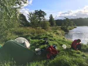
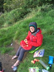
The sun was shining and it was perfect. We got the tents up (it was a squeeze to get them both in but they fitted!) and dried them out while fetching some water and making a celebratory cup of tea. We even had a little grassy bank/ledge to sit comfortably on! It was so nice to be able to have plenty of time to relax, drink tea, cook dinner etc without the rush of getting to bed or getting out of the rain, a welcome treat after our last few nights’ camping! We even finally got around to stewing the apples that Bracken had given us (the newest trial of my stove!) along with some blackberries picked from around our camp. Now that’s what I call dessert! The colours as the sun started to go down were beautiful – oranges and silvers and blues – and reflected on the water, silhouetting the trees on the other side. Incredibly peaceful. It grew cold quickly once the sun started to drop, as it always does, so it was fairly quickly into tents and sleeping bags. It’s amazing, camping out here. There is something about wild camping which for me is what camping is all about – getting out in nature. None of this camping in a field surrounded by lots of other people and tents with no view!

It’s another shorter day tomorrow as we are aiming for the only campsite between here and Glasgow, and then it will be a longer day for the final stretch. But that means we can enjoy our lovely camping spot for a bit in the morning before we go!