Total miles: 17.1
Elevation gain: 1,584ft
Time walking: 8:30am – 6:30pm
Miles to date: 968.6
What a delightful day! Wet, windy, chilly, but delightful!
We got ourselves up early as we had a long day ahead, packing the majority of our things away whilst still in the tent as it was on and off drizzle and also blustery and chilly up on the hill. There is something amazing though about emerging from your tent in the early morning, to a beautiful view, with no one else around, and making a cup of tea which you clasp close to keep warm. The tents went away pretty wet but we didn’t worry too much as we knew we had a bed for the night tonight, a real luxury after 5 nights camping!

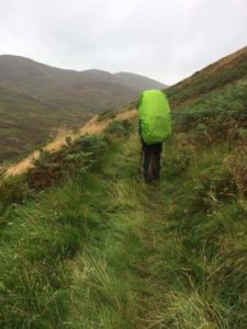
Wrapped up warm in long sleeved tops and waterproofs, buffs around our ears to keep the wind out, we shouldered our packs and headed up to the path, meeting a couple of trail runners on the way who looked very wet and muddy. The path wandered through an old settlement – nothing but big grassy lumps and bumps on the hill now – then down the other side of the saddle along a muddy path to a small road which wound around the bottom of the hill. The trees at the bottom were showing their autumn colours, beautiful but also strange as part of me feels like it should still be summer, despite the growing chill in the air, heavy dews and darker evenings.
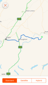
The path followed the road for a couple of miles, past a fast flowing stream, pretty hillside and free-roaming sheep before heading back into field-come-moorland. It was a squelchy, uphill trudge and one very large field had both sheep and cows. At one point a cow started running down the hill in our direction, which made my heart quicken; I didn’t much fancy chasing off cows but I was more worried for Anneliese as she is terrified of them! Thankfully it turned out the cow was just running to her friends at a salt lick and wasn’t headed to us at all. Phew! Eventually the path reached the highest point of that particular section and started to track downhill towards the tiny village of Stobo. Stobo Castle, just down the way and visible on the hillside from where we were, is apparently a nice hotel and spa. How tempting! The John Buchan Way took us in the opposite direction though, heading up past cute little cottages and along a pretty stream running through light woodland, back towards the hills. We found a nice spot for a break to crack open Anneliese’s peanut butter and munch on our oat cakes. We had planned to get some water from the stream to filter but couldn’t find a suitable spot to actually get to the water without getting either very wet or very muddy, or both! Whilst falling in the river would have made for a good story, neither of us fancied doing the honours… Thankfully a bit further on the path actually crossed the stream at a little bridge by an old ruined cottage, and was much more accessible!
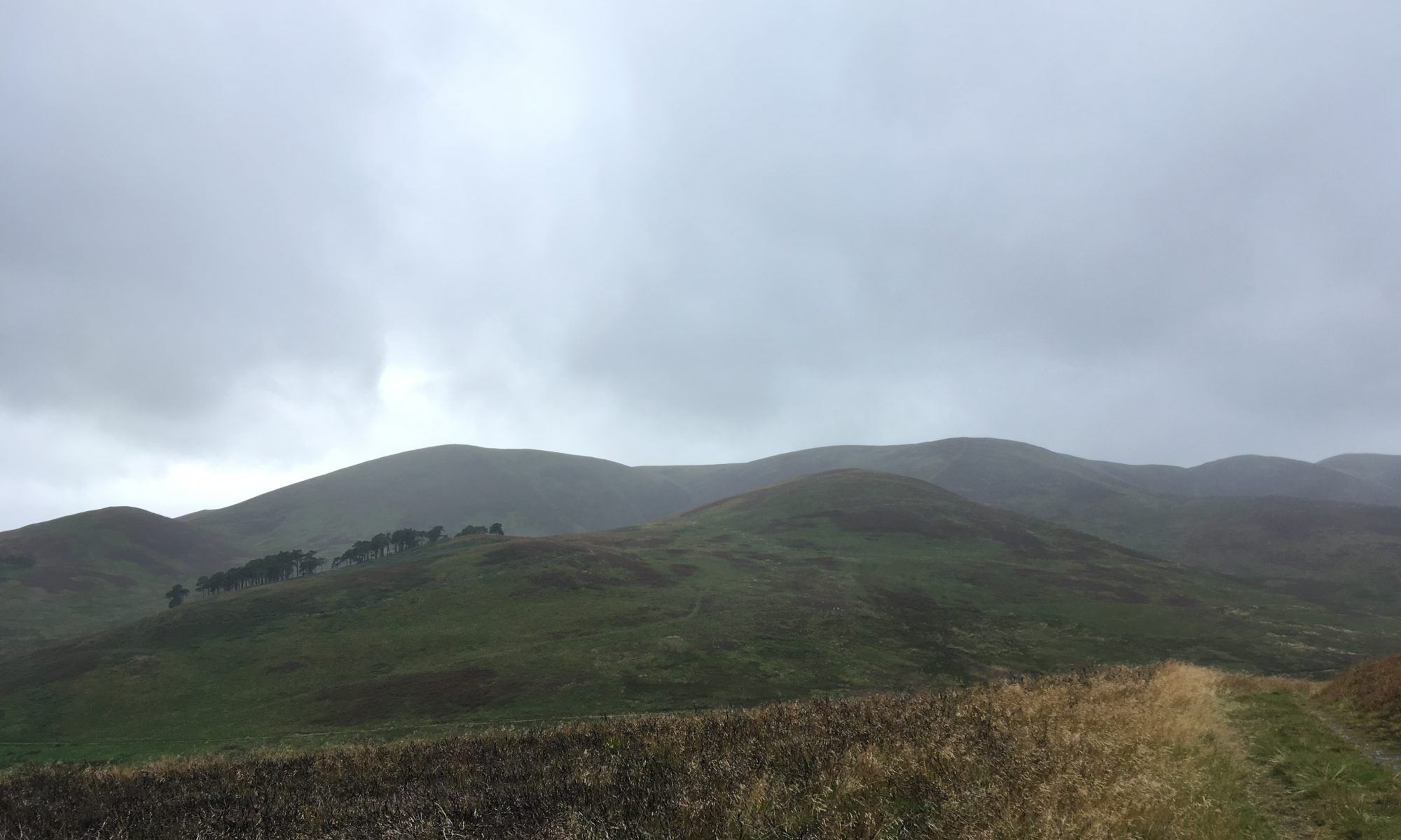
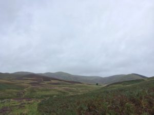
From here the path got more remote and beautiful, climbing up higher between the hills and then walking along the edge of a stunning valley. It was on and off drizzle all the way but always just a bit too light and short lived to really warrant the waterproofs so we just got a little bit wet each time! It was blustery too, and often we had to work hard to keep our balance. Thankfully the path didn’t actually go over the hills, at first glance on the map it looked like a potentially very hilly day so it was quite a pleasant surprise to not have too many climbs, even if the couple we did have still felt tough enough! It was a beautiful section of the path, it really felt like we were walking on the edge of the world. In places it was almost reminiscent of parts of the Pennine Way, muddy paths and all, just not quite as high up!
As we dropped down into the quiet valley we spotted a remote cottage, Stobo Hopehead, right in the middle of the flat open space between the hills with only a rough track leading up to it. Sadly it didn’t look occupied, but it was amazing to think that someone might (have) live(d) all the way out there! It would make an awesome bothy! The wind really picked up as we climbed up a narrow, boggy track up to the head of the next valley over and we couldn’t talk because it flew away with our voices and made our eyes and noses stream! We had a quick rest on a bench at the top with a great view down the winding valley into which we were about to descend, purple and orange heather on the hillside and green grass at the bottom, the occasional white dots of distant sheep scattered over the slopes.
Descending was a slippery business but incredibly pretty with the hills towering each side of us and countless streams gushing off the hillsides. A mile or so later we came across hints of civilisation – a field, a barn, and then a man and his dog, followed by a proper track and then the turrets of a (modern-ish) castle! It was another mile down to the village of Broughton, past some nice farm buildings, a water wheel and a grand tree-lined road. And when we reached the village – the happy sight of a tearoom! We walked in gratefully, suddenly really hungry, as well as muddy and a bit wet around the edges! I had a baked potato with chilli con carne and Anneliese had a macaroni cheese, plus a lovely hot cup of tea (or three…). Then we shared an almond slice. The food didn’t last long, it was so good! We got chatting to several of the other customers who were curious about where we were walking, and picked up some more donations! It’s lovely to be back in civilisation occasionally even just to meet new people who donate to the causes I’m supporting, as that was something that didn’t happen a lot along the Pennine Way!
While we were having our tea I double checked the rest of the route, expecting it to be another 10 miles as that was what I had written in my plan. I was surprised, pleasantly so, to realise it was only in fact 6 miles! Confused, I measured it again, wondering how on earth I’d got that wrong. On reflection, I think I must have read somewhere that it was 10 something from Broughton to Biggar along the old railway line, and taken it to be miles when actually it was kilometres! Glad it was that way around…!
Having prepared ourselves for 10 miles suddenly 6 seemed like a walk in the park, especially along the easy, flat, grassy track. Halfway along we were glad it was only 6 though, as we were starting to tire and 10 miles of straight and flat would have become a little tiresome! The surrounding hills were pretty though and the early evening light made pretty patterns in the sky. A couple of miles from Biggar we saw a massive black cloud over the town – it was definitely raining there… We watched the cloud start to head our way and realised we were going to get wet! We didn’t bother with our waterproof jackets as we’d managed without them all day (I had kept my waterproof trousers on all day though), but after a while we realised we probably should have put them on – it was a much heavier and longer shower than the others! But soon we spotted the caravans that marked the campsite on the edge of town, near to where we were meeting Jan and Allan, our hosts for the night. We arrived looking rather wet but still smiling, of course, excited at the prospect of a hot shower, home cooked meal and a bed!
Now all our wet gear is hanging up in the garage, we’ve washed our dirty clothes, washed ourselves (ohh that shower was sooo good!), wrapped ourselves up in fluffy dressing gowns, been fed delicious food and wine and are now falling asleep at a ridiculously early time of day! Tomorrow is a rest day, which almost feels cheeky after having had a rest day only four days ago, but we are now back on track and a rest day is always useful for catching up on anything that needs catching up on, restocking our food supplies and just giving our bodies a bit of a break. And no doubt there’ll be lots of nice hot cups of tea!