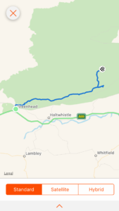
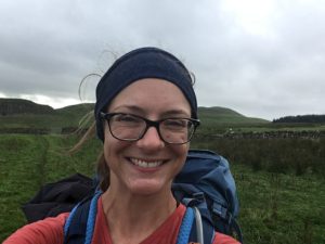
Total miles: 13.5
Elevation gain: 2,080 ft
Time walking: 11:30am to 6:30pm
Miles to date: 830.3
Oh my goodness what a stunning day! They say that yesterday is worth it because it brings you to today and I have to say I completely agree! Today was Hadrian’s Wall, a real milestone in my journey. I can now say I have walked the length of Britannia – Roman Britain! It was a brilliant walk today but not an easy one, lots of ups and downs equal only to the coast path. I was thankful that I was splitting the journey from Greenhead to Bellingham (officially one section) into two by staying at the bothy overnight. A lot of people do it in one go (there are limited accommodation options en route unless you stay somewhere along the wall) and that would make it a very long day!
I decided to set off a bit later today as I was really feeling the last few days of long tough walking and I knew it wasn’t the longest day. The pub did breakfast so I made the most of that and as I wandered back to the hostel I spotted Sean sat in the cafe. I popped in to say hello and we swapped stories from the last couple of days. I was reassured to find that he had found yesterday pretty arduous too! He didn’t know about the bothy that I was planning to stay at so I pointed it out on his map and he circled it excitedly, saying he’d take a look.
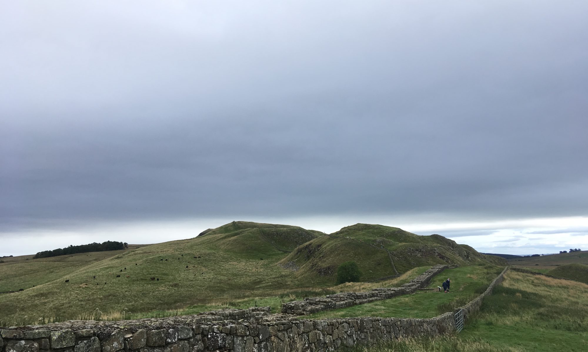
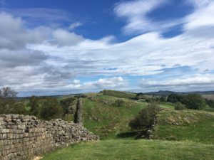
Eventually I set off and after a short riverside footpath I reached the ruined Thirlwall Castle and joined the Hadrian’s Wall Path. The path climbed steeply up onto my first section of wall, only an earth bank at this point, with fine views, a strong wind and a hot sun. Wow, summer’s back! It was beautiful walking. The wall often curves slightly so you can see it stretching away to the east for miles, up and down over the whin sill escarpment, with expansive sweeps of wilderness on either side. It is a stunning sight! It is also challenging walking. The first few ups and downs were exciting and satisfying, soon I realised that they didn’t lie when they said Hadrian’s Wall Path is a constant series of ups and downs! Sometimes I’d look ahead and half gasp in admiration at the beautiful crags, half sigh in exasperation at the prospect of yet another set of steep climbs. On the flatter sections I power-walked to make up some time so I could take my time along the prettier, harder sections.
It was certainly the busiest section of my walk for a long time, being a sunny bank holiday there were lots of people out walking the wall, albeit mostly confined to 100m either side of the car parks! I met a couple of people actually walking the Hadrian’s Wall Path. The long distance walkers are easy to spot – and it’s not just the big rucksack which sets them apart – they have a slightly weatherbeaten and tired but usually happy expression, muddy boots and various bits of gear or clothes hanging off their packs to air or dry (socks or towels are the favourite). This point marks roughly the halfway point for them and apparently it is one of the best bits. It’s a path I’ve always wanted to do and at ‘only’ 84 miles it now seems very doable. I’m not sure about all those ups and downs though…!
At Winshields Crags, the highest point along the whole of Hadrian’s Wall, there is the option of detouring down to Twice Brewed to the pub (and hostel and campsite where people who break the long section usually stay). I’d debated popping to the pub for some lunch or a drink but it looked a long way down, and what goes down must come back up. Also it felt like I wasn’t making as good time as I’d hoped, even though I wasn’t walking particularly slowly. I guess it’s down to the distance covered on the map being very different from the distance you actually walk if you were to flatten out all the hills. It certainly felt like I had walked a lot further than the 7 or 8 miles Strava told me I had covered! Still, it was only a couple of miles to the point where the Pennine Way leaves the wall and the bothy was only a mile or two beyond that, so it looked like the day would end up being shorter in mileage than I’d first calculated.
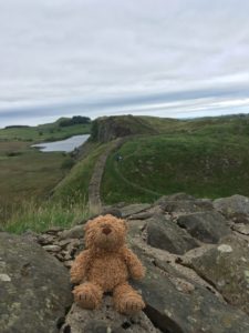
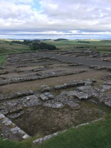
I pushed on and after a few more stiff climbs I made it to Rapishaw Gap, where the path leaves the safety of the wall and heads off into the wilderness beyond. It was still reasonably early so I decided I’d continue on for another half a mile and check out Housesteads Fort, supposedly one of the best preserved roman forts of them all. I first went to the little museum and treated myself to an ice cream and coffee (I couldn’t decide between hot or cold so went for both…!), as I couldn’t face walking down the hill to the visitors centre where there was a proper cafe. Excitingly the museum and fort are English Heritage (and National Trust) so my new membership (purchased at Launceston Castle all the way back in Cornwall) finally came in handy again and I enjoyed spending an hour wandering around the tiny museum and watching the short film, learning a bit more about the fort and the Romans in general. They were a pretty impressive bunch! It’s incredible how refined and ‘modern’ they were, nearly 2000 years ago, and I wondered what on earth happened to progress in the thousand or so years in the middle! The museum had some amazing pieces of pottery, tools and weapons and it was fascinating to think about how old they were. After the museum I wandered around the fort itself, which is basically a series of impressive stone walls and building foundations which give a clear indication of the layout of the buildings – barracks, granary, hospital, administration centre and commanding officer’s house. I still can’t get my head around the fact that those walls were nearly 2000 years old, and over 800 roman soldiers and their families lived here. The wall certainly must have some stories to tell!
After the welcome refreshment and history stop it was time to retrace my steps the short distance to Rapishaw Gap and head out beyond the wall. It felt quite strange, to head over the wall and out into the lands beyond! I wondered what it must have felt like all those years ago, leaving the relative safety of the wall to venture into the lands of the barbarians. It certainly felt like crossing a frontier, even today, after the busyness of the wall the sparse lands to the north felt lonely and adventurous. The path crossed a series of ridges running parallel to the wall, gradually bringing me down to lower altitude so that the wall disappeared from view fairly quickly.
A bit of fiddly route finding across some fields (clearly there is at least a little bit of civilisation nearby) and then the path heads up into the huge Wark Forest and shortly after this the footpath to the bothy branches off from the Pennine Way. The bothy is only about half a mile off the path but as usual remains hidden until the last few metres. As I rounded the last corner and spotted the little building, on the edge of the forest overlooking a shallow valley and craggy hills beyond, I was excited to see smoke coming from the chimney – someone had the fire going already! Crossing my fingers that it was a friendly fellow hiker and not a group of drunken rowdy lads (rare but not unheard of), I headed around to the front door and stuck my head in. Friendly fellow hiker, phew! And, not too surprisingly but very welcome, was the sight of Sean’s rucksack on another of the chairs. Reassured that I would be sharing the bothy with two people who clearly knew what they were doing, I plonked my bag down and introduced myself. Michael is a regular user of the bothy and was just out here for a few days for a quiet break. He told me of the best place to get water, a small spring about 100m away in the middle of a field which I would never have known to look for, let alone find, without his directions. He offered me some of his water but me being Miss Independent wanted to go and fetch water herself, so off I trotted. His directions were very good. If you ever happen to stay there, turn left out of the door, over the stile and head diagonally down through the field not quite to the other side, and the spring is by a small stake about 2 metres in front of a taller stake. It’s nothing more than a trickle out of a small pipe, and if Michael hadn’t have cleared it of weeds it would have been easy to miss (unless you stepped into the boggy pool it flows into!). It was crystal clear and cool and although I still filtered it first, it made a change to not be drinking slightly peat and tannin-stained water!
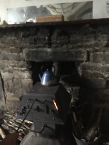
I triumphantly returned to the bothy with my full water bottle and found Sean had returned from wherever he had been. He said he had originally only popped in to see what the place was liked but he liked it so much he decided to stay the night. It certainly is a lovely hut. There are four single bunks and one double, with two small tables, several chairs and a wood burning stove that made the room very cosy. The guys had the kettle going on top of the stove so there was plenty of hot water for a cup of tea. Oh I was in my happy place! We all made our respective dinners, I had a rehydrated vegetable hotpot and the guys used the super hot stove top to cook packets of pasta and rice. It was the perfect evening of conversation, happy munching, fire gazing, reading and just quiet appreciation of the company of likeminded individuals. As it got darker Michael brought out some tea lights and surrounded the room in a lovely warm glow. This is just heaven!
I’m half tempted to take my rest day here, a day early, but with limited proper food and the need to take a bit of time to restock etc in civilisation I’ll need to head on tomorrow. Thankfully it is a much shorter day, only 11 miles, which means I can spend a leisurely morning here. I have a feeling I’ll leave rather reluctantly though!