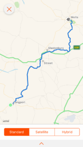
Total miles: 22.7
Elevation gain: 1,619 ft
Time walking: 9:15am – 7:15pm
Miles to date: 261.1
Days walking: 16
Today was a really lovely day. It was long but beautiful and my feet and legs held out well!
I wasn’t sure how today was going to pan out at first. After a fairly good night’s sleep (I woke up a few times thinking I’d fallen asleep mid-walk and had to get up and keep walking…!) and an amazing full English breakfast thanks to Rich, I set off feeling refreshed and renewed however my pack felt seriously heavy. I couldn’t work out why. I knew I was carrying the new nutrition supplies but I wasn’t carrying excessive amounts of water or anything else, so I put it down to just having softened up on my rest day! I was a bit apprehensive though, knowing how far I had to walk today (and at that point I was expecting it to be 19 miles). Thankfully after a few miles the pack started to feel a bit more normal, so I must have just taken a while to get used to it again!
Heading out of Langport my first footpath was blocked off thanks to the Somerset Steam and Country Show so I had a bit of a diversion along the road, but at least I didn’t have to retrace my steps this time. My route took me along the Woodbirds Hill track which skirts a pretty hill to one side and an orchard to the other and although the vegetation was long (and wet, after the rain!) it was a nice track to follow, the air was all fresh and clear after more rain overnight and the day was looking promising.
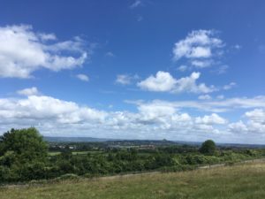
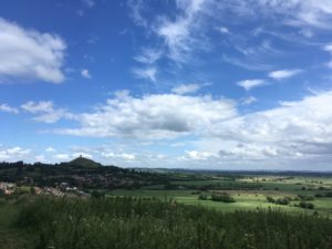
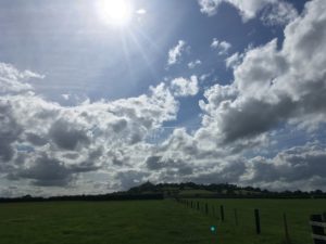
Dropping down to a long, straight road then tracking due north along the levels I was expecting the next hour or so to be a bit monotonous, but actually it wasn’t at all. There were hills to aim for, the light was beautiful, there was a nice breeze, lots of pretty willow trees, ripe blackberries, puddles to dodge and the ground was nice and soft after the rain. So I made really good progress towards the Polden Hills and even the climb up wasn’t too shocking. The view from the top however was stunning! The Polden Hiils form a ridge separating the levels around Langport from the levels around Glastonbury and I could look back from where I came and, for the first time since Dartmoor, I could see my onwards route as far as tomorrow morning! Glastonbury Tor stood high and proud out of the levels and it was exciting to know I’d be up there later this afternoon.
Even though my feet were feeling pretty good I stopped for a rest with my boots off and enjoyed sitting in the sun admiring the view. I was satisfied with the time I had made, which made a bit of a change! The next bit of the route took me down through fields of horses, where I made friends with a foal who I am convinced was a mule (horse crossed with a donkey). Whatever he was, he was very friendly, or at least very curious, and wanted to nibble everything! When I got to the first few houses a smell suddenly stopped me in my tracks. I looked around and then saw it – a eucalyptus tree! You don’t often see them in this country (although there was one in our garden growing up) but what amazed me was how striking the smell was, even from over 100m away! It suddenly felt like I was walking in Australia!
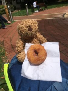
It took about a mile of walking through the quieter bits of Street to reach the high street. Street used to still be classed as a village (the largest in England apparently) despite its size, I’m not sure if it has now made it to town status but it really should have. I wandered along the high street and then up through Clarks Village where I decided to stop for a coffee and doughnut. It felt slightly bizarre being there as I went to college in Street and we also used to come here as children and spend the day at the outdoor pool, which is still there but looking distinctly less busy than how I remember it.
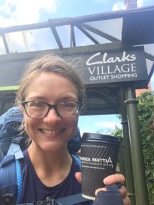
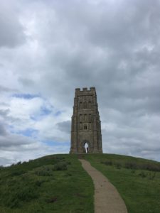
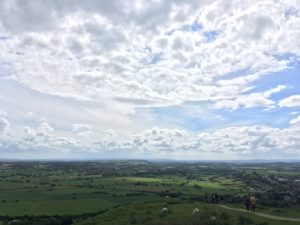
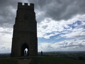
Leaving the bustling Clarks Village I took the main road out of towntowards Glastonbury then cut up onto Wearyall Hill, a small ridgeway which has some great views and cuts out a section of busy road into the town. I had some more great views of the tor and as I got closer I could make out the winding path and the people on top of the hill. It was definitely a (planned) diversion but I couldn’t go to Glastonbury and not climb the tor, it was one of my favourite things to do as a girl. The way up had me out of breath but wasn’t nearly as tough as I remember…possibly just me getting fitter…but the views were just as good as I remembered! The Somerset Levels just stretch out for miles in every direction, at sea level, and I tried to imagine what it would have looked like when the levels were covered with water, or even mist. Even today you could see the weather varying in different directions, one moment the sun would be shining on Exmoor and rain would be threatening over the Mendips, and then it would shift and the sun would briefly highlight my destination, the tiny city of Wells.
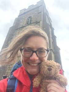
There were lots of people out on the hill and it was very windy, so I didn’t stay too long after eating my lunch but I dropped down the other side feeling very glad I’d taken the diversion! My route from the Tor took me east for a few miles before turning to head towards Wells. I couldn’t cross the five miles as the crow flies due to all the water channels (rhynes) crossing the moor, so it was a big loop around, slightly frustrating when you can see your destination right there tantalisingly close in front of you!
Still, it was a pleasant walk and there were fabulous views back to the tor. After a few miles I headed north again, and I realised that it was the first time this trip I had actually been walking north for any significant length of time! I initially twigged the change in direction when I realised that the sun for once was shining on my left arm, not my right arm (seriously, my tan lines aren’t just dodgy, they are lopsided!). It was quite gratifying to know I was now making some headway northwards, rather than just eastwards!
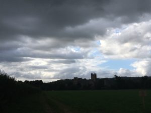
I had a couple of footpath-not-being-obvious-or-easily-accessible moments but thankfully at one potentially sticky spot involving a stream a friendly farmer spotted my confusion and came to help me out. They’re not all bad! The main issue was that I was running very low on water (I’d forgotten to refill in Street, oops!) and there was nowhere really to refill. It’s amazing how conscious you get of how much you drink, when you don’t have much left! As if in answer to my water troubles the sky suddenly darkened and it threatened rain. I spoke to the weather gods very nicely and asked if they could hold off until I reached Wells, and I am very grateful that other than a little drizzle (which gave Wells cathedral a very “huddled down” look about it), the threatening clouds remained nothing more than that!
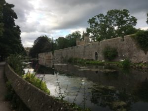
And so, a little later than intended given that the day turned out to be over 22 miles, starting to feel it in my feet (but thankfully nowhere near as badly as I had in Taunton), I walked into Wells past the Bishop’s Palace and along its lovely streets to arrive at tonight’s bed for the night, with the lovely Vanessa who is a friend of a friend, with dinner ready on the table and a big glass of water, perfect!
I was very good and did a good stretching session tonight, and although my feet ache and my blister is just beginning to grumble again, I think they should be ok by tomorrow. “Only” 14 miles tomorrow…and I might stop off at Wookey Hole Caves on the way!
Night night x