Total miles: 12.9
Elevation gain: 652 ft
Time walking: 10:15am – 5pm
Miles to date: 1,383.6
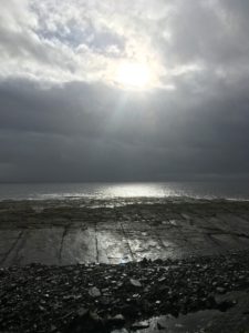
I’m pleased to report that day 101 was considerably better energy-wise than day 100! Whether it was the restful B&B, the bath, this morning’s pre-workout drink (my last sachet…I’d been holding out until I really needed it!), the slightly easier path or just because, after the initial aches and pains and stiffness I seemed to get into my stride again. It started off wet and wild in Wick, with a wet and blustery trip around the headland, and ended up a stunning (but still blustery) day walking along the gorgeous Sinclair Bay. Funny how it turns out!
As all good days should start, breakfast was plentiful and delicious, brought to my room on a tea trolley and eaten overlooking the harbour where the sun was making a halfhearted attempt to break through the clouds, creating beautiful scenes in the sky. The walk started by heading into the town along the busy marina where yachts, fishing boats, wildlife cruise ships and ferries all bobbed along together. Wick itself looked grey, all the buildings hunkered down against weather that hadn’t yet appeared. I’m sure on a sunny day it looks much more cheerful, and perhaps if I was feeling slightly perkier and my feet didn’t hurt suspiciously I would be more inclined to appreciate it! My feet weren’t just aching this morning, there was actually a pain in my left foot, along the bones of my mid-upper foot. It hurt to press it, and I’m not sure my feet were thrilled to be stuffed into my boots again. I hoped that once I got going they’d warm up and relax a bit (thankfully they did seem to, but every time I stop and the boots come off it gets a little more painful!). It sounds terrible, but it really wasn’t that bad really. Just the worst it has been so far!
I had to pop into town to pick up a few last supplies – enough chocolate, flapjack and nuts to see me through to the end, and something for lunch. As I stood in front of the chocolate aisle I had a funny realisation. This would be my final chocolate bar selection! While I’ve been walking chocolate has been a daily habit. Before this trip I very rarely bought chocolate bars (I’m a good quality dark chocolate girl usually!) but it’s easy calories and a brilliant pick me up – physically and mentally – at sticky points in the day. But I wouldn’t be walking any more, in two days’ time! At least not to the extent that it required daily chocolate bars. Which left me with a tough decision….which two chocolate bars would it be?! Chocolate bars selected and some exciting bits picked up for lunch – I went one step better than my usual ham when I found an exciting pack of cheddar cheese sticks with a Branston pickle dip! Ham, cheese and pickle wraps it is then. And a last bag of crisps. A few odds and sods more and I went to pay. As I took my card out a voice behind me said “Here, I’ll get that for you”. I turned, amazed. The kind guy behind me told me he’d seen my picture on Facebook and therefore knew I was doing my big walk, and wanted to buy my shopping for me. I was so touched, such kindness! That really gave me a boost, and I had a nice warm spot in my heart all day!
Oh, and it was a Twix and a biscuit and raisin Yorkie 😉
The first couple of miles out of Wick were wet and blustery but thankfully not that cold. I was actually quite enjoying the wildness of it, watching the waves crash along the shore. I had been planning to camp tonight but I had just been put in touch with Neil who lives directly on the trail further north and had offered to put me up. With weather like it currently was, a bed and hot shower was a tempting prospect!
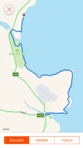
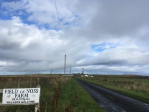
Out of necessity the route follows the little road out to Staxigoe for a few miles which was not the most interesting section but was at least straightforward and even! Staxigoe wasn’t the prettiest place (I have to say the houses up here all look a bit ugly from the outside…functional but not beautiful!) but its harbour was lovely. A useful information board told me that at one point it was the busiest herring-processing harbour in Europe! The road ended here and turned into the driveway of Field of Noss Farm, notable for its “walkers welcome” sign and the great view of the Noss Head lighthouse beyond. The walk then followed seaside fields overlooking shallow cliffs with crashing waves. I wonder if the sheep knew what a great view they had?! Approaching the lighthouse a huge wall cut across the field with only one way through – a rather innocuous looking gate. As I drew closer the gate resembled something out of a Krypton Factor challenge… The gate was crooked and rusty but the main obstacle was the huge pool of water and deep soft mud spreading out several metres from the gate on both sides. I tested the mud with my pole and it sank about half a foot. It didn’t look promising! I poked about a bit more and found some spots that were slightly less deep, aimed for the gate and made a dash for it. The damage wasn’t too bad…my feet were already slightly damp anyway… then on climbing the gate the far side wasn’t actually as bad.
Not quite as muddy as I feared, I headed across towards the lighthouse and then suddenly noticed a large stretch of water to my left. At first I was a little confused, and I wondered if there was a loch I hadn’t noticed on the map, and then it twigged – it was the vast Sinclair Bay. Sure enough as I gained some height the rest of the bay stretched out in front of me, and, to my amazement and excitement, I suddenly realised that I could see Duncansby Head beyond the end of the bay. That’s the headland just beyond John O’Groats, the most north-easterly point of mainland Great Britain, my end point! The end was literally in sight! Just beyond I could see one of the Orkney islands, which gave the impression the mainland just kept going. I was glad it didn’t, even though it was amazing how close Duncansby Head looked. Still, I had the vast bay to skirt first, and my finishing point for the day was two-thirds of the way around it.
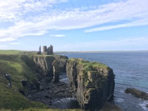
There were a couple of distinctive points of interest making themselves visible along the way. Firstly the ruins of Castle Sinclair Girnigoe, then beyond that the stately Ackergill Tower. And then the long stretch of sandy beach flanked by a tall narrow ridge of dunes, the only break in the sand being the River of Wester, not visible from this far away. It all looked at once achievably close and remarkably far away but as I made my way along the cliff tops everything started to gradually creep closer. First stop was the castle, with several of its ruined buildings intact enough to visualise how the castle might have looked in its heyday. It was built on an outcrop of land which was virtually a sea stack and a bridge took me over the deep ditch guarding the entrance. It would have been an impressive place to live, for sure!
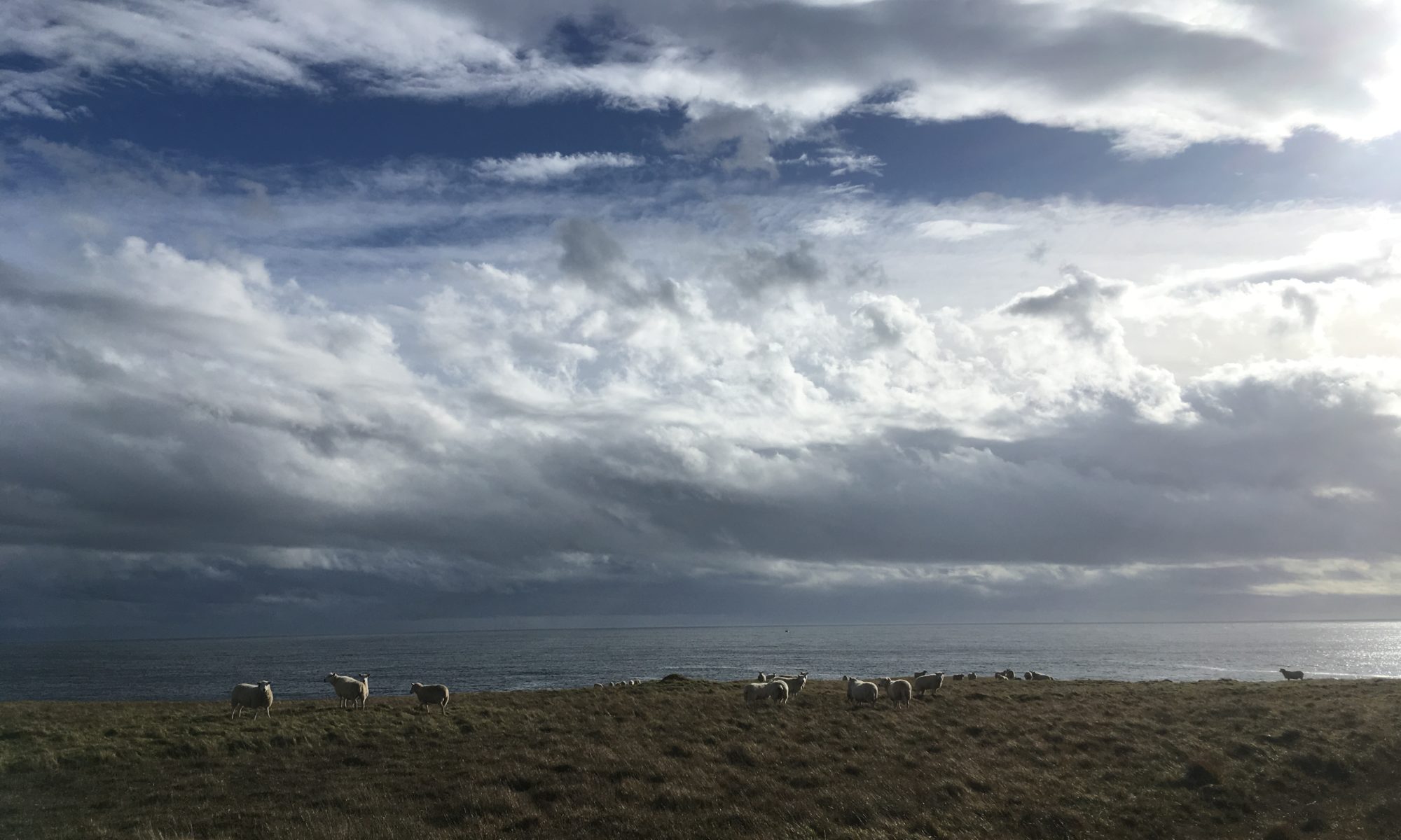
A semi-clear path led from the castle to a lovely beach at Ackergill. There was a gorgeous flat grassy spot just above the beach that I thought would make a beautiful camping spot, until I noticed all the cow tracks around…maybe not! Today the field was empty, thankfully. I seem to be getting quite lucky on the cow front at the moment. Cows up here aren’t so used to humans and you have to be a bit more careful near them, however a lot of the fields which clearly often contain cattle were miraculously bovine-free! Without the threat of being trampled by cows I wandered along by the beach enjoying the sunshine, spotting a couple of seals, a mum and her pup, doing the same. Enjoying the sun, that is…they certainly weren’t wandering! They were doing what every sensible being should be doing on a warm sunny afternoon, lazing about, looking very comfortable on their rock!
The path led into the little hamlet of Ackergill and then through a field to Ackergill Tower (a posh hotel). Unfortunately I spoke too soon on the cow front and discovered a small group of cows, plus big ugly bull, waiting at the opposite end of the field…right by my exit gate. I warily ventured into the field and headed their way, keeping close to the fence in case I needed to beat a hasty retreat. I made it about two thirds of the way along when one of the cows got nervous and shied away. That got the bull’s attention and he gave me a long hard look and then, with an almost audible sigh as if I was dragging him away from something very important (to be fair, he did look like he was doing a bit of flirting with the cow next to him), he started to take a few steps towards me. That was enough of a hint for me – I was over the fence and wall in a flash! I made my way down to the other end and the cows all watched me suspiciously from the other side of the wall. I was somewhat dismayed to find a damp, nettle-covered ditch beyond the wall at the other end. To get out I had to climb up onto the wall, shimmy along, pick my way over some barbed wire, then climb down by the gate I had originally aimed for. A bit of a palava, but I’d made it in one piece, and un-trampled by scary bulls, which was rather satisfying!
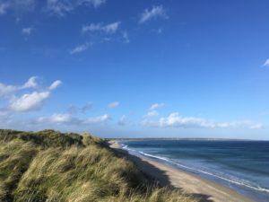
The path beyond the tower was almost a let-down – easy and obstacle free! On the plus side it came out onto the stunning beach just a little further on, and it was the perfect afternoon for it. Sun, blue sky, blue sea and a strong breeze blowing the tops of the waves backwards in a spray of white. It was incredibly picturesque and reminded me of Druridge Bay in Northumberland where the cover picture for this website was taken! I took the path through the tall dunes which wound around a little but was very pretty. It was also incredibly windy! At points I wondered whether I’d get blown off the top! A little further on the path took me down into the beach and I enjoyed walking along the water’s edge, but was glad I hadn’t walked the whole way on the sand as it was soft and hard going.
A while further and I reached the dreaded River of Wester. I had been apprehensive about this river – the biggest on the trail – since Loth Burn. There are several warnings about it – normally at low-ish tide it should be easily wadeable along the beach but at high tide or in spate it can get up to chest deep! The tide was only half in but I took one look at the river and it was an easy decision to take the inland route. It may well have been fine but I wasn’t taking any chances!
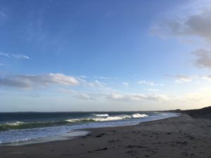
The inland route was a bit of a pain – finding the way into and across the golf course to a gate onto farmland, then cutting through fields to join the A99 to cross the road bridge – but it was safe at least. I also got to see a little of the Subsea 7 factory, a place where they make undersea pipelines in sections 7km long, then use a railway line to feed them into the sea! It was only a brief spell on the road then I cut back towards the sea through the dunes. The sun had gone from this section of the beach but it still shone on the sea and on the village of Keiss up ahead. There were massive rollers coming in from the sea and I wondered what they’d be like to surf. Not that I can surf, but I could imagine that those waves might have been pretty good! I took a while to make my way down the beach as I kept stopping to look at the amazing waves, especially when the wind blew the spray backwards off the top of the waves. White horses galloping onto the shore!
The beach marked the end of my day and I was almost sad it was over. Neil, who I am staying with tonight, met me at the car park. He needed to pop to Wick to pick up a few things for dinner and it amused me how quickly we got there – a matter of minutes, after it had taken me 7 hours to walk! It was interesting to see the route from the car too, the way I would have walked had it not been for the JoG trail. It was still scenic, but had nothing on the coast path! The rest of the evening was very pleasant and definitely far more civilised and comfortable than if I had camped. Neil is a great cook and the multiple courses (including two rounds of dessert!) went down very well, although I fear I may now have to roll myself to the finish line!
Tomorrow is the final full day and it feels a bit strange to be honest! It shouldn’t be too challenging a day, the path starts getting a little more regularly worn at this end and it shouldn’t be a long day either. I’m just hoping the weather holds out as I’m planning to wild camp for my last night…currently the forecast shows heavy rain during Saturday night and all day Sunday…not really the weather I wanted to finish in but ah well, what will be will be!